

A War of Deep Intel
Today, we will explore a crucial perspective on the current conflict with Iran. What follows touches the core dynamics shaping this war.
Let’s first rewind to the morning of Monday, December 8, 1941—a cold, damp day in Washington, D.C. The sky was gray, light rain fell, and temperatures hovered in the mid-30s (F).
On this day, President Franklin Roosevelt was prepared to address a Joint Session of Congress, seeking a formal declaration of war against the Empire of Japan following their surprise attack on Pearl Harbor the previous day. This marked the start of a significant chapter in world history.
At the same time, another important event unfolded within the capital, though with far less attention. That December morning, a group of Navy and Army officers arrived at the National Geographic Society’s headquarters on 16th Street, just north of the White House.

Headquarters of National Geographic Society, 1930s. Courtesy NGS.
A custodian opened the building’s front doors. The officers requested a meeting with Gilbert H. Grosvenor (1875-1966), president of the Society, whose tenure encompassed much of the institution’s history. Since the 1920s, Grosvenor had transformed the National Geographic Society from a casual gathering of adventurous travelers into a respected center of research and publishing focused on geography, archaeology, and related earth and cultural sciences.
Grosvenor welcomed the unexpected visitors with respect and asked how he might assist.
The senior officer responded, “Sir, on behalf of the President of the United States, we would like to know if the National Geographic Society has maps of Japan that it will make available to the Navy and Army for this upcoming war.”
The question implicitly revealed a serious flaw in America’s military preparedness: the Navy and Army lacked adequate maps.
It wasn’t just maps of Japan that were missing; up-to-date, detailed charts were absent for Korea, China, Indochina, many Pacific Islands, India, and Australia. Additionally, updated maps of Greenland, Iceland, Europe, the Soviet Union, North Africa, the Middle East, South America, and the rest of Africa were also in short supply.
In essence, as the U.S. entered World War II, its War and Navy Departments—then separate cabinet entities—were missing fundamental resources vital for “expeditionary warfare,” including accurate maps of foreign territories where naval and ground forces would operate.
Fortunately, a private organization—the National Geographic Society—held valuable map archives worldwide. This connection brings us back to the present, where we delve further…
War Is Intel
It has been four weeks since Israel and the U.S. initiated military operations against Iran, and media coverage remains scattered, if you’ll pardon the phrase given today’s context. There are numerous perspectives but confirmed facts remain elusive, which is typical during wartime when operational and tactical information is closely guarded.
U.S. Central Command (CENTCOM) reports that American forces have targeted nearly 10,000 locations within Iran, utilizing missiles, long-range standoff weapons, precision-guided munitions like JDAM, and traditional gravity bombs—now feasible as Iranian air defenses have been partially disabled. Images of B-1 and B-52 bombers suggest extensive destruction inflicted on Iranian assets.

U.S./Israel air strikes in Iran. Courtesy BBC.
On the opposing side, Iran has responded with waves of missile and drone attacks, although their frequency seems to be decreasing over time.
Iran has targeted Israel and various U.S. bases throughout the Middle East, as well as civilian and industrial sites in Arab countries stretching from Jordan to Oman and nearby nations.
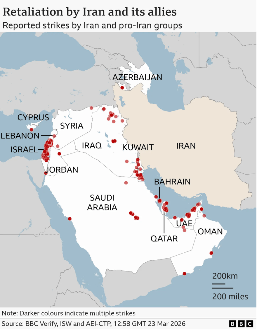
Iran attacks on U.S./Israel targets, and other Gulf nations. Courtesy BBC.
What insights can we draw at this point? Every air and missile strike reflects some degree of intelligence on its specific targets. This implies a thorough program of data collection that includes mapping, grid references, GPS coordinates, AI-assisted targeting, laser designations, and more.
In the current era of combat, neither the U.S., Israel, nor Iran rely on resources like the National Geographic Society’s maps from 1941. There is no longer any need to request maps from travel or geographic publications.
Instead, U.S. and Israeli forces manage extensive “geographic information systems” (GIS), combining multiple layers of detailed information from high-level overviews to granular data.
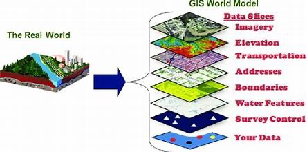
GIS: Geographic Information Systems. Courtesy animalia-life.club.
It all begins with a base map, similar to those found in world atlases at bookstores. From there, GIS adds detailed layers including road construction quality, bridge weight limits, and infrastructure like power grids, pipelines, pumping facilities, valves, and chokepoints.
Data catalogs fixed military and industrial locations, pinpointing crucial control centers, supply caches, and equipment. There’s even information specifying who resides in particular apartments, the floor, and precise window locations—details sometimes crucial for planning drone missions.
Iran also possesses sophisticated maps and solid intelligence. Their missile strikes demonstrate accurate targeting ability on key Israeli military bases, industrial hubs, and important venues throughout the Arab world.
Evidence suggests that some Iranian missile impacts on civilian neighborhoods in Tel Aviv, Haifa, or Dimona may have aimed at residences of senior Israeli political, military, or scientific personnel. Similarly, drone strikes on Gulf hotels appear to have been targeted toward rooms housing U.S. and European military and defense-related guests.
A key point is that every bombing or missile strike is not an isolated incident: the explosion is the final result of extensive intelligence work, sometimes accumulated over decades.
Collect and Archive
Consider, for instance, reports of air strikes on missile-filled Iranian caves. Such hits require years of persistent monitoring to observe excavation activities, estimate volumes of rock removed, and track construction equipment. Advanced methods are almost certainly employed to determine tunnel directions and depths.
All this information is archived systematically, stored in vast, redundant computer databases with numerous cross-references. When commanders plan an attack, the relevant data is accessible immediately—far removed from the era of needing to visit National Geographic’s offices.
Before striking any target, teams of intelligence analysts and ordnance specialists select an exact location—often accurate to the nearest square meter. They also identify the most appropriate weapon, considering size, charge type, fusing, guidance systems, and delivery method.
Once a target and weapon are chosen, multiple command levels review the operation, verifying the rationale: why the target is selected, the mission’s objectives, and the risks involved for personnel or equipment delivering the ordnance. Nothing is accidental in such operations.
In other words, military targeting has come a long way since World War II when Jimmy Doolittle planned his Tokyo air raid in 1942 using National Geographic maps.
The evolution is even clearer compared to the Vietnam War era, when B-52 “Arc Light” missions dropped vast numbers of unguided bombs over wide areas with the hope of causing damage. Although powerful, such tactics often lacked precision and efficiency.
Nowadays, delivering munitions relies heavily on intelligence—often “deep” intelligence—that extends well beyond the immediate target.
Many strikes are opportunistic, initiated when a drone identifies a target and quickly releases a weapon. Yet, even such actions depend on prior intelligence: why the drone was deployed to that area, what ordnance it carries, and how the operators possess sufficient data to approve a strike.
Ultimately, every airstrike embodies years of surveillance, analysis of imagery from space and other sources, and intelligence gathering from human and electronic channels. When conflict erupts, it falls to policymakers and commanders to prioritize targets from extensive lists and select suitable weapons.
Targeting processes have grown increasingly automated. Most potential targets are processed through extensive databases of geographic and industrial intelligence collected over decades, all narrowed down to precise points on or beneath the surface for munitions to reach.
This is where firms like Palantir (PLTR) are vital, offering software and algorithms that speed up analysis while sifting through vast troves of historical and current data. As the phrase goes, “Put warheads on foreheads.”
There is more to discuss, but this overview aims to enhance appreciation for the intelligence underpinning headline events and to clarify the deep data driving much of what unfolds.
Eventually, the conflict with Iran will conclude. The side possessing superior intelligence will ultimately prevail.
Thank you for subscribing and reading.