
America 250: Birth of a Post-Glacial Nation
This week holds special significance: on Saturday, we mark the 250th Independence Day, commemorating the moment when the United States officially emerged as a nation.
The story of progress stretches from Jerusalem to Athens, then Rome, on to London, and finally Philadelphia. The historical weight here culminates on July 4th, 1776. Yet, it represents far more than just a single date on the calendar.
America’s path toward Revolution started during the 1760s post-Seven Years’ War, passed through years of imperial turmoil, and escalated to armed conflict at Lexington and Concord in 1775.
At the same time, 1775 saw the Continental Congress form the Army in June, the Navy in October, and finally the Marine Corps in November. Hence, even before nationhood, the military forces were already established. (“Which is exactly as it should be,” some might say.)
Hostilities continued from 1775 to 1781, concluding with Yorktown, while the Treaty of Paris in 1783 secured peace. Subsequently came the Articles of Confederation, the drafting of the 1787 Constitution, ratification a year later, and George Washington’s inauguration in 1789.
Clearly, building the new nation was a process that required patience. One of the earliest formal actions of the fledgling government was the addition of the Ten Amendments, the Bill of Rights—arriving just in time!
This week is an ideal occasion to reflect on America’s past. But there’s an additional dimension to consider: geology. Put simply… How 1776 marked the Birth of a Post-Glacial Nation. Let’s explore that further…
Welcome to a Post-Glacial Continent
When Europeans reached North America’s Atlantic shore, they encountered a terrain profoundly shaped by the Ice Age. Though Pleistocene glaciers had receded around 10,000 years earlier, they left behind polished bedrock, mineral outcrops, lake basins, moraines, kettle ponds, marshes, submerged river valleys, and sand and gravel deposits—including the massive freshwater Great Lakes system.
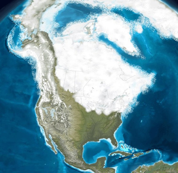
North American Pleistocene ice cover, 1.8MY – 10,000 yrs ago. Credit U.S. Geological Survey.
While post-glacial geology didn’t dictate American history outright, it shaped major factors influencing communication, settlement, farming, transportation, industry, military strategy, and westward expansion. For indigenous peoples and newcomers alike, the landscape affected plant and animal life, migration routes, trails, habitation zones, agriculture, and economic activities.
America’s Glacial Inheritance
During the Pleistocene, ice sheets moved repeatedly, covering regions including New England, New York, northern Pennsylvania, the Great Lakes states, parts of the upper Midwest, and western mountains.
These glaciers ground and polished bedrock, deepened valleys, altered drainage, and transported debris known as till. As they melted, powerful flows relocated boulders, gravel, sand, silt, and clay across outwash plains, deltas, floodplains, and lake beds.
For Native Americans and European settlers, these glacial movements resulted in landscapes characterized by fertile lowlands adjacent to rocky uplands, navigable waterways alongside challenging overland paths, and plentiful construction materials next to thin soils.
A Post-Glacial, Coastal Nation
By 1776, due to rugged bedrock and difficult terrain, European colonization had scarcely penetrated the North American interior. Settlements were mostly coastal or clustered along rivers emptying into the ocean.
Colonial and Revolutionary America’s culture, economy, and politics centered around towns and small cities nestled in drowned river valleys: Boston and coastal Massachusetts, Narragansett Bay, New York harbor, Philadelphia on the Delaware, Baltimore on the Chesapeake, and Charleston farther south.
This pattern aligns well with the geological explanation—glacial meltwater caused sea levels to rise and flood river mouths, creating the inlets that formed harbors, ports, and colonial entry points.
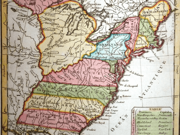
Colonial-Revolutionary America, a seacoast phenomenon. Credit Library of Congress.
In New England, the glacial legacy was especially harsh—more unforgiving than any monarch’s rule. Glaciers stripped away soil, exposing ledges and fields strewn with boulders, drumlins, ponds, and rugged uplands.
These conditions limited large-scale farming, encouraging small family farms, woodlands, livestock raising, fishing, shipbuilding, and town commerce.
Consider New England’s iconic stone walls: more than charming countryside features, they represent decades of labor as farmers cleared glacial stones from fields and built these durable barriers. This landscape shaped the patterns of agriculture and land ownership season after season.
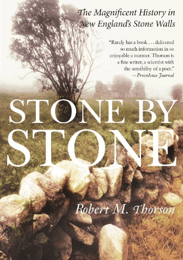
Stone by Stone: The Magnificent History in New England’s Stone Walls. Robert Thorson. Credit Amazon screen shot.
Yet post-glacial features also offered benefits. Ice and meltwater carved coves and estuaries, producing natural harbors essential for maritime commerce. Boston, Newport, Portsmouth, and other coastal towns thrived thanks to these advantageous positions.
Further inland, steep slopes and streams powered sawmills, gristmills, and small factories. Water wheels transformed timber, grain, ores, and other raw materials into finished products long before the advent of coal-fueled industrial power.
In essence, New England’s rugged, ice-shaped terrain limited farming but fostered a diverse economy based on seafaring, crafts, industry, and urban centers. This contrasted markedly with the South, where plantation agriculture predominated and industrial growth lagged, shaping distinct social and economic paths.
Glacial Geography of Westward Expansion
After 1776, U.S. expansion faced major geological hurdles. The Appalachian Mountains—formidable even today—posed a significant barrier along the coast.
Physical geography governed movement, as did influencing drainage patterns left by the glaciers. Ancient meltwaters restructured rivers and carved valleys that formed natural migration and transportation corridors for Native peoples, trappers, traders, soldiers, and settlers.
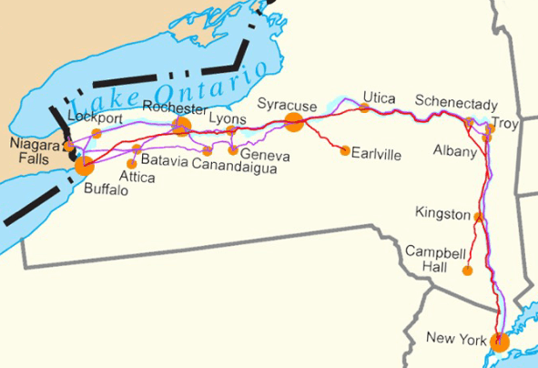
Hudson-Mohawk Valley/Erie Canal route. Credit msnikkijones.weebly.com.
By the early 19th century, New York’s glacially carved Hudson-Mohawk corridor transformed native trails and waterways into a vital thoroughfare. This route connected the Hudson River to Albany and westward via the Mohawk-Erie Canal to Buffalo and the Great Lakes—America’s inland sea.
The Erie Canal, an engineering marvel, was grounded literally in a landscape molded by bedrock and glacial history that made east-west passage feasible.
Where canals were absent, portages between watersheds reflected glacially shaped geography, facilitating movement from the St. Lawrence to the Great Lakes and into the Ohio and Mississippi river basins, both heavily influenced by ice age forces.
Strategically, the push westward was a quest to comprehend and harness the interior’s immense geological water systems, exemplified by Lewis & Clark’s expedition down the Ohio, up the Missouri, across the Continental Divide, and down the Columbia to the Pacific.
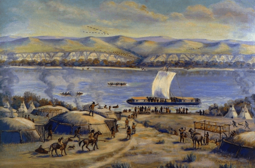
Lewis & Clark Expedition on Missouri River. Credit Smithsonian Institution.
Similarly, the Great Lakes stand as the most striking post-glacial feature on the continent. Their immense basins are carved from bedrock deepened by glacial erosion, filled by meltwater to form an inland ocean.
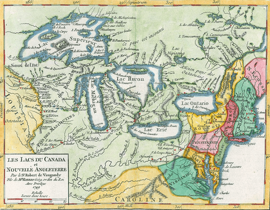
Early map (1749) of Great Lakes region. Credit University of Notre Dame, Hesburgh Library.
By the 1780s, leaders understood that controlling the Great Lakes meant access from the St. Lawrence Seaway deep into the interior. Benjamin Franklin even traveled to Montreal to encourage the French to support the American rebellion (they declined).
Control over lake routes was crucial for trade, diplomacy, and military strategy, especially given British Canada to the north and hostile Native nations nearby.
The Northwest Ordinance of 1787 codified the lakes’ role in national growth, opening states like Ohio, Indiana, Illinois, Michigan, Wisconsin, and Minnesota to settlement and commerce.
Meanwhile, glacial outwash across the Midwest deposited minerals and sediments such as quartz, feldspar, limestone, clays, creating fertile soils enriched over 10,000 years by prairie grasses and native wildlife. This made the region exceptionally productive farmland.
Combined with the capacity to ship grain and ore eastward via the Great Lakes, the post-glacial interior provided a foundation for economic prosperity.
Minerals and Mines
Post-glacial processes also profoundly shaped America’s mineral wealth by exposing ore deposits formed deep in geological time. The Keweenaw Peninsula of Michigan offers a prime example, where copper formed 1.5 billion years ago from Precambrian volcanic and hydrothermal activity associated with the Midcontinent Rift.
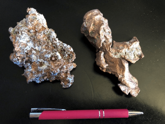
Keweenaw elemental copper, mined (L) and “float” (R). BWK collection.
Though the copper deposits themselves pre-date the Ice Age, Pleistocene glaciers scoured away overlying soil, revealing bedrock outcrops and carrying fragments of native copper known as “float.”
Native peoples had long been familiar with Keweenaw copper, and by the 1840s, it sparked the first major industrial mining boom in America. Ore was shipped across the Great Lakes to Pittsburgh and other industrial hubs with abundant coal, fueling a regional metals economy. Later, similar routes moved Minnesota iron ore throughout the industrial Midwest.
California provides another mineral case: the Sierra Nevada’s quartz veins contained gold. Glacial erosion and meltwater concentrated gold in stream gravels, ultimately leading to the 1848 “Eureka” discovery at Sutter’s Mill.
The ensuing Gold Rush attracted large populations westward, transforming California and turning San Francisco—also built along submerged valley systems—into a major global city.
Wrap-Up: America the Post-Glacial Nation
There is much more to explore, but the essential takeaway is that the United States did not emerge on a geologically blank canvas. Instead, it was forged upon a continent where ice, meltwater, rising seas, erosion, and sediments had pre-shaped the physical environment.
Long before independence, the land was marked by coastal inlets, river valleys, fertile plains, rocky highlands, mineral exposures, lakes, and mountain ranges. These were conditions inherited rather than chosen.
It’s no exaggeration to state that post-glacial geology influenced virtually every aspect of early American development: determining suitable harbors, town locations, viable farmland, mill sites, transportation routes, mineral extraction, and military positioning.
Places like Boston, New York, Philadelphia, the Hudson-Mohawk corridor, Erie Canal, Great Lakes, Keweenaw copper, and California gold were far from random historical details—they reflected a profound geological legacy that shaped social, economic, and political growth.
While we honor the Declaration, Revolution, and Constitution as the architectural pillars of American history, beneath those lies a foundational physical context—bedrock, soils, waterways, ports, ores, and paths—much sculpted by ice and post-glacial processes.
Though geology didn’t craft the Constitution or fight the Revolution, America’s post-glacial landscape made some paths more accessible and others more challenging, influencing outcomes in significant ways. Thus, while the nation was founded in 1776, its origins extend back 10,000 years to the shaping forces of a post-glacial continent. Since then, the country has continuously adapted to this inheritance.
That’s all for now. Happy America 250!
Thank you for subscribing and reading.